NABI SAMWIL
The majority of the 1000 inhabitants of Nabi Samwil were expelled in 1967 by the Israeli authorities. Those who remained were put into few houses and the village almost completely demolished. No construction has been authorized since. The village has been connected to the water network in Ramallah in 1986, while the two sources of the village were requisitioned by the Israeli authorities. Its connection to the electricity network dates from 1981. As in Hebron, a part of the mosque was confiscated and converted into a synagogue. It is forbidden to enhance the roads, schools and install public lighting. Located 5 km northwest of Jerusalem, the village is separated from Ramallah by the wall, which it’s administratively attached. Living in Area C, under Israeli military control, its 200 inhabitants are undergoing constant military invasions.
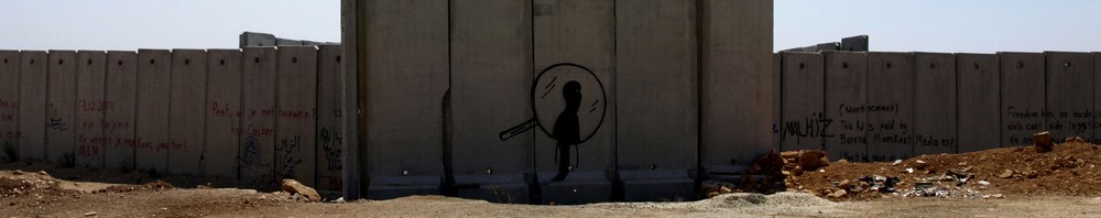
The first belt way
![]()
« The first belt way of the Greater Jerusalem » is created by the 142 km wall which encloses the eastern part of the city. Stretching 14 km in the West Bank, its sinuous route includes the majority of settlements and land on the Israeli side, with few Palestinians. The Wall isolates the towns, villages, and Palestinian neighborhoods from each other and from the rest of the West Bank. It also prohibits the free movement of residents while settlers enjoy reserved direct highways to Jerusalem, Tel Aviv and the Dead Sea. It is considered illegal by the UN and the International Court of Justice (ICJ).
ABU DIS
The village of Abu Dis, 3 km south-east of Jerusalem is cut in two by the wall. Its western part is integrated in the Israeli Municipality of Jerusalem. The heart of the village (15 000 inhabitants, from which 10 000 of them are students and employees of Al Quds University), connected to Jerusalem for centuries is now trapped behind the wall and surrounded on the east by the Ma’ale Adumim.
RAMALLAH
The Ramallah district has 220 000 inhabitants. Since 1995, the town contains, aside from the many NGOs, institutions of the Palestinian Authority. The partial lifting of occupation, the professionalization of Palestinian security forces, and financial perfusion provide up to 20% of people in the free area (zone A) the benefit of prosperity and relative calm. For the others living in refugee camps on the outskirts of Ramallah (zone B), the horizon is the wall that looks like being inside a prison: 60 000 Palestinians in this area live in neighborhoods split apart by the wall and settlements. At the Qalandia checkpoint, there are four main crossing points between the West Bank and Jerusalem, 24,000 people wait patiently each day in long queues to reach their workplaces, their schools, and their families.
BETHLEHEM
![]()
The Bethlehem district has 140,000 Muslim and Christian inhabitants. Towards the east, the arid hills plunge toward the Dead Sea. Towards the south lies the wide settlement bloc of Gush Etzion. Towards the north and west of Bethlehem, the wall annexes large areas of land to East Jerusalem settlements and encloses Aida refugee camp. A road surrounded by walls topped with watchtowers stretches from the city all the way to Rachel’s Tomb.
To reach Jerusalem at 10 km, Palestinians must pass through the north checkpoint of Gilo. The ride begins in a sordid warehouse where you sometimes wait for hours. You advance through the narrow corridors and Israeli soldiers shout orders in Hebrew through the overhead speakers. On the other end, a turnstile intermittently opens, letting only 10 people pass at a time. Another queue then leads to another turnstile where soldiers confirm identities behind armored window; they will either refuse passage or wave you through the checkpoint with a head nod. While most travelers present identification documents or permits, some can use magnetic cards or place their hand onto scanners to cross. Israeli citizens cross the checkpoint quickly with no stops and then are back onto a reserved highway that connects Jerusalem to the settlements in the south of the city.
The second belt way
« The second beltway of the Greater Jerusalem » consists of multiple settlements located beyond the wall, within a 40km radius around Jerusalem. The majority of land in this region is classified as zones B and C (under Israeli control) and the inhabitants are targeted by very aggressive settlement policies: confiscation of land for installation and expansion of settlements, civilian and military infrastructures (roads, walls, fences, watchtowers, checkpoints …), restricted movement, banned demonstrations, violence against property and persons, army raids, and even imprisonment of activists.
GUSH ETZION
The settlement Bloc Gush Etzion extends from the south-east of Jerusalem to the north of Hebron and from the Green Line to the Judean Desert. Composed of twenty settlements (60,000 settlers) and 20 outposts (created without approval but often with the help of the Israeli government), it prevents any territorial continuity between Bethlehem and Hebron. For Israelis, Gush Etzion is attractive due to its location only 20 km from Jerusalem to which it is connected by a system of roads and tunnels that bypass Palestinian towns. Settlers in this settlement have advantages over the Palestinians. The cities of Bethlehem, Beit Jala, Beit Sahour, many villages and two refugee camps (230,000 people) are included in the zone of the Regional Council of Gush Etzion. Five Palestinian villages (20,000 people) end up in enclosed inside the bloc of settlements. There are many assaults taking place on Palestinians, their cultures and their olive trees are uprooted, even their animals are poisoned. In 2010 there were over 200 various forms of barriers (barriers, earth banks, concrete blocks, checkpoints …).
MAALE ADUMIM
![]()
Third largest Israeli settlement, Maale Adumim, 7 km east of Jerusalem, is a key element of « the second belt of the Greater Jerusalem ». Its 40,000 inhabitants are connected to West Jerusalem by bypass roads, have a large industrial and commercial area, cultural and educational institutions, and green parks. East 1, an extension project of the settlement sits on 53 km2 (half of Paris), will expropriate new land to build roads, recreation, commercial and residential areas, a recycling site, quarrying…etc. Prejudging the result of ongoing negotiations on borders and status of Jerusalem, this extension will prevent any continuity between the northern and southern West Bank, making the viability of the future Palestinian state problematic. The East 1 project was validated by the Israeli government on November 29, 2012, the same day Palestine became an observer member in the UN.
HERODION
The Herodion, also called Jebel Fourdeiss -little paradise mountain, Jebel Khreïtoun -Mount St. Chariton, Jebel el-Franj -the mountain of francs, is probably the most impressive palace-fortress of King Herod the Great. Edified between 24 and 15 BC, the palace and the city symbolized royal power. According to the historian Flavius Josephus, it was here that Herod was buried. The site was occupied twice by Jewish Zealot insurgents, from 66 to 70 AD and during the Bar Kokhba revolt from 132 to 135, rebels chose suicide as at Masada rather than the roman sword or crucifixion. The site was reoccupied during the Byzantine period and during the time of the Crusaders. This historic site and the surrounding lands were confiscated by the Israeli government.